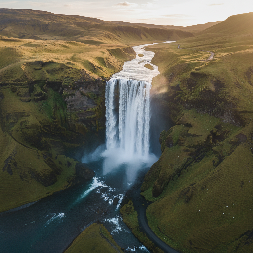
Dynjandi, also known as Fjallfoss, is one of Iceland's most spectacular waterfalls, located in the remote Westfjords region. Unlike the more famous Gullfoss or Seljalandsfoss along the south coast, Dynjandi offers a unique multi-tiered cascade that drops a total of 100 metres (330 feet) over a series of seven distinct shelves. Its width at the top is about 30 metres, but it fans out to nearly 60 metres at the base, creating a bridal-veil effect that has made it a favourite among photographers and hikers alike.
This article provides a comprehensive guide to Dynjandi, covering its geology, how to reach it, the best hiking trail, nearby attractions, and practical tips for your visit. If you're planning a trip to the Westfjords, Dynjandi is an unmissable stop. For a broader overview of Iceland, see our complete guide to Iceland 2026.
Geology and Formation of Dynjandi
Dynjandi is not a single waterfall but a series of seven cascades, each with its own name and character. The main drop, Fjallfoss, is the largest and most photographed. The total height of the cascade system is 100 m, with the highest single drop being about 30 m. The falls flow over a series of basalt steps that were formed by successive lava flows during the Miocene and Pliocene epochs, roughly 5–15 million years ago. The softer sedimentary layers between the basalt have been eroded by glacial meltwater, creating the stepped profile visible today.
The water originates from the Dynjandisá river, which drains from the nearby glacier Drangajökull, the only glacier entirely within the Westfjords. The river carries glacial silt, giving the water a milky turquoise hue on sunny days. The volume of water varies seasonally; peak flow occurs during the summer melt from June to August, while winter flow is significantly lower and parts of the falls may freeze.
How to Get to Dynjandi
Dynjandi is located in the southern part of the Westfjords, about 20 km southeast of the village of Flateyri and 70 km northwest of Ísafjörður, the region's largest town. The waterfall is easily accessible via Road 60, a paved road that connects the southern and western parts of the Westfjords. From the main road, a short gravel road (Road 624) leads to a parking area with a toilet and information sign. The drive from Ísafjörður takes about 1 hour, and from Patreksfjörður about 1.5 hours. For a detailed itinerary, see our 5-day Westfjords itinerary.
The Westfjords are less visited than the south coast or the Golden Circle, but the roads are generally in good condition during summer. However, many roads are gravel and can be rough; a 4x4 is recommended but not strictly necessary for Dynjandi itself. In winter, Road 60 may be closed or require 4x4 with winter tyres. Check road.is for current conditions.
Parking and Facilities
- Parking: Free parking lot at the trailhead, capacity about 30 cars. In summer, it can fill up by midday; arrive early (before 10:00) to avoid crowds.
- Toilet: A dry toilet is available near the parking area. No flush toilets; bring hand sanitizer.
- Entry Fee: None. Dynjandi is a natural site and free to visit.
- Picnic Area: Benches and tables are provided near the parking lot. No food or drink vendors on site; bring your own supplies.
The Hiking Trail: Seven Tiers, Seven Views
The trail to the top of Dynjandi is a 1.2 km (0.75 mile) one-way path that climbs about 100 m in elevation. It is well-maintained with wooden steps, gravel, and some rocky sections. The hike is moderate in difficulty and takes about 30–40 minutes one way, depending on your pace and photo stops. Sturdy walking shoes are recommended; the path can be slippery when wet. The trail is accessible from late June to September; outside that, snow and ice may make it impassable.
As you ascend, you pass each of the seven tiers. Here they are from bottom to top:
- Bæjarfoss – the lowest tier, a wide curtain of water.
- Hundafoss – a narrower cascade.
- Hæstafoss – the tallest single drop (approx. 30 m).
- Stóri foss – broad and powerful.
- Hrútafoss – a ram's head shape in the rock.
- Fjallfoss – the main drop, also called Dynjandi proper.
- Hænufoss – the uppermost tier, small but scenic.
Each tier offers a different perspective. The spray from the falls creates rainbows on sunny days, especially in the afternoon. The best light for photography is in the late afternoon when the sun illuminates the falls from the front. For safety, stay on the marked path and avoid climbing on the slippery rocks near the water.
Nearby Attractions in the Westfjords
Dynjandi is just one of many natural wonders in the Westfjords. The region is known for its dramatic fjords, bird cliffs, and hot springs. If you're spending a few days in the area, consider these nearby destinations:
- Patreksfjörður (45 km west): A charming fishing village with a swimming pool, restaurants, and the Icelandic Sea Monster Museum. Population about 650.
- Latrabjarg Bird Cliffs (70 km west): Europe's largest bird cliff, home to millions of seabirds including puffins (best seen June–August). The cliffs stretch 14 km and reach 440 m in height. See our guide to when puffins are actually there.
- Rauðasandur Beach (80 km west): A unique red sand beach, contrasting with the black sands of the south coast. Access via a rough gravel road; 4x4 recommended.
- Ísafjörður (70 km east): The Westfjords' main town (pop. 2,600), with a vibrant cultural scene, restaurants, and the Westfjords Heritage Museum. It's a good base for day trips.
- Vigur Island (near Ísafjörður): A small island in the fjord with puffins, eider ducks, and a historic windmill. Accessible by ferry from Ísafjörður (tours around 8,000 ISK per person).
- Hot Springs: The Westfjords have several natural hot pots, such as Krossneslaug (a geothermal pool with ocean views, 30 km north of Dynjandi) and Hellulaug (a small pool near Flókalundur).
For a detailed route, see our 5-day Westfjords itinerary that includes Dynjandi, Latrabjarg, and more.
Practical Tips for Visiting Dynjandi
To make the most of your visit, keep these tips in mind:
- Best time to visit: Late June to early September. July and August offer the warmest weather and longest daylight (up to 20 hours). In September, crowds thin but weather is more unpredictable.
- Weather: The Westfjords are notoriously windy and rainy. Bring waterproof jacket and pants, warm layers, and sturdy shoes. Even in summer, temperatures rarely exceed 15°C.
- Pack a picnic: No food is sold at Dynjandi. The nearest grocery stores are in Flateyri (20 km) or Þingeyri (30 km). Pack sandwiches, snacks, and water.
- Respect the environment: Stay on marked trails, do not litter, and do not disturb wildlife. The area is fragile and protected.
- Fuel up: The nearest petrol stations are in Flateyri (N1, open limited hours) and Þingeyri (Orkan). Fill up before heading into the remote areas.
- Accommodation: Options near Dynjandi include guesthouses in Flateyri (e.g., Guesthouse Flateyri, from 15,000 ISK per night) and camping at the Dynjandi campsite (basic facilities, about 1,500 ISK per person). For more comfort, stay in Ísafjörður or Patreksfjörður.
Dynjandi in Winter
Visiting Dynjandi in winter (November to April) is possible but challenging. Road 60 is often covered in snow and ice, and the trail to the falls is not maintained. The waterfall may freeze partially, creating stunning ice formations, but access is dangerous. Only attempt with a 4x4 vehicle, winter tyres, and experience driving in Icelandic winter conditions. Check road.is and vedur.is for updates. For winter travel tips, read our Ring Road in winter guide (though Dynjandi is off the Ring Road, the principles apply).
Dynjandi vs. Other Icelandic Waterfalls
Iceland is famous for its waterfalls, but Dynjandi stands out for its unique tiered structure. Here's how it compares to other major falls:
- Gullfoss: A massive two-tier cascade (32 m drop) on the Golden Circle. More accessible and crowded. Dynjandi is less visited and more remote.
- Seljalandsfoss: A single drop (60 m) that you can walk behind. Located on the south coast, very busy. Dynjandi offers a hiking experience.
- Skógafoss: A wide 60 m drop on the south coast. Famous for its rainbow. Dynjandi is taller overall and less commercial.
- Svartifoss: A 20 m drop surrounded by black basalt columns, in Skaftafell National Park. Dynjandi is larger and more multi-faceted.
- Dettifoss: Europe's most powerful waterfall (44 m drop, 500 m³/s) in Northeast Iceland. Dynjandi is less powerful but more scenic in a different way.
For a broader comparison of waterfalls along the south coast, see our 3-day south coast itinerary.
Conservation and Responsible Tourism
Dynjandi is part of the Dynjandi Nature Reserve, established in 2003 to protect the waterfall and its surroundings. The reserve covers about 100 hectares and includes hiking trails, picnic areas, and a small campsite. Visitors are asked to follow Leave No Trace principles: pack out all trash, do not pick plants, and avoid disturbing the fragile moss and soil. The area is home to arctic foxes and nesting birds; keep dogs on a leash.
The Westfjords receive far fewer tourists than the south or the Golden Circle, but numbers are growing. In 2023, approximately 150,000 visitors came to the Westfjords, with Dynjandi being the most popular single attraction. To minimise impact, consider visiting early in the morning or late in the afternoon to avoid peak crowds (usually 11:00–15:00).
Conclusion
Dynjandi is a must-see for anyone exploring the Westfjords. Its seven-tiered cascade, accessible hiking trail, and pristine natural setting make it one of Iceland's most rewarding waterfall experiences. While it requires a detour from the main tourist routes, the journey through the dramatic fjords and remote villages is part of the appeal. Plan your visit for summer, pack for all weather, and take time to absorb the power and beauty of Fjallfoss.
For more inspiration, check out our 5-day Westfjords itinerary and complete guide to Iceland 2026.
Related Articles
- Westfjords Iceland: 5-Day Itinerary Off the Tourist Trail
- Latrabjarg Bird Cliffs: When Puffins Are Actually There
- The Complete Guide to Iceland 2026
- Iceland Ring Road: 7, 10, 14-Day Itineraries 2026
- Ring Road in Winter: What's Open and What to Skip