The Glymur Waterfall Hike, the Log Across the Botnsá, and When It Is Not There
The Glymur waterfall hike crosses the Botnsá on a log that is only in place during summer. Here is what the trail demands and when the log is gone.

The Glymur Waterfall Hike is Not a Casual Stroll, Especially When the Log is Gone
Most visitors assume Iceland's second-tallest waterfall is a straightforward walk to a viewpoint. It is not. The Glymur waterfall hike demands a steep ascent on loose scree, a river crossing on a single log with a guide rope, and a route that only exists in full from June to September. Outside those months the log is removed. The hike becomes a there-and-back on the east side only, and the Botnsá river can be dangerous to approach. This page covers exactly when the crossing is in place, what the trail demands in every condition, and how to avoid the most common failure: attempting the loop when the log is gone or the river is up.
Glymur Hike Log Crossing: the One Obstacle That Defines the Route
The log across the Botnsá is the central feature of this hike and the main reason hikers fail. It is a single felled trunk, roughly 30 centimetres wide, with a fixed rope handline on one side. The log is placed in early summer and removed before winter. There is no official precise removal date; it depends on snowmelt and park crew schedules. In 2025 the log was in place from the first week of June through the third week of September. That window is typical.
When the log is there, you cross it near the trailhead, climb the steep east side to viewpoints above the canyon, then cross the Botnsá again at the upper crossing and descend the west side for a loop of roughly 7 km. When the log is gone, you cannot cross the lower Botnsá safely. The only option is a there-and-back on the east side, which means you climb to the viewpoints then descend the same way. That route takes 3 to 4 hours but skips the west-side canyon views.
The Botnsá runs cold, near snowmelt temperature. If you attempt to wade it when the log is absent, the current and temperature create real risk. Do not cross. Turn back or stay on the east side. The first east-side viewpoints and the cave area still give a full day out without crossing the river.
Glymur Trail Difficulty: Harder Than Most Expect
The Glymur trail is moderate to challenging, not an easy walk. The round-trip distance is roughly 7 km with a steep climb on the east side. The surface is loose scree and wet rock in sections. Hiking boots with grip are required; trainers without tread slip on the scree and on the wet rock near the river. The hike takes 3 to 4 hours for most people, but add time for the river crossing and for the descent on the west side if you do the loop.
Two specific sections catch hikers out. The first is the initial climb out of the valley: a steep, narrow path over loose stone where a slip means a long slide. The second is the upper Botnsá crossing on the loop, which involves stepping stones rather than a log. In high water those stones are submerged. If the water covers them, do not attempt the crossing; reverse your direction and return via the east side.
Weather Change Is the Real Danger
Hvalfjörður weather turns from clear to rain and wind faster than the forecast suggests. The fjord's steep sides funnel wind, and rain can arrive within ten minutes of a blue-sky start. Fog is the most common failure after the river: if cloud drops over the canyon, the viewpoints disappear and the trail becomes hard to follow. Turn around at the cave area or by the first viewpoints if visibility drops. The trail is not clearly marked above the tree line, and an offline map is essential because mobile signal does not reach the trailhead.
Route marking on the east side is reasonable in clear weather: small cairns and occasional posts. On the west side, markings are sparser. Make the turn-back decision early. The hike is still worth doing as a there-and-back; pushing into fog or wet rock at the upper crossing is not.
How Long is the Glymur Hike: Distance, Time, and What Changes by Month
The Glymur round-trip distance is roughly 7 km for the full loop and about 5 km for the east-side there-and-back. The hike takes 3 to 4 hours in dry summer conditions. That stretches to 4 to 5 hours if the ground is wet or icy, which it can be in June and September.
The hike season runs roughly June to September. In June the ground is often wet and soft from snowmelt. The log may be in place by the first week but conditions underfoot are slippery. By July the trail is dry on the east side. August is the driest month but also the busiest: the first weekend, Verslunarmannahelgi, brings Icelandic families to the area, and the parking area can fill by mid-morning. September brings colder temperatures and the risk of ice on the upper sections. The log is usually removed in the third or fourth week of September, sometimes earlier if snow comes early.
In October the hike is possible only as a there-and-back on the east side if conditions are dry, but the ground is wet, icy, or snow-covered in sections. From November to March the trails are icy, river crossings are dangerous, and the side roads can be impassable. Avoid that window for hiking Glymur.
Shoulder Month Ground Condition
Wet, soft, or icy ground depending on month and weather. Check road.is for side road conditions and en.vedur.is for the forecast for Hvalfjörður. If the forecast shows rain or temperatures below 5°C, the upper trail will be icy by mid-afternoon. Turn back before the cave if ice is present.
Glymur Waterfall Parking: Where it Is, When it Fills, and What You Need to Know
Glymur waterfall parking is an unpaved car park at the end of the Botnsdalur road. The drive from Reykjavík to the trailhead takes roughly 1 hour via Route 1 north and then Route 47 into the fjord. You must take Route 47 around the fjord, not the Hvalfjörður Tunnel, because the tunnel bypasses the entire fjord and drops you on the far side. The tunnel saves 45 minutes but skips the trailhead. The tunnel is free.
The parking area has no facilities. No toilet, no shelter, no information board with current conditions. The parking capacity on summer weekends fills by mid-morning, especially in July and August. Arrive by 08:30 to guarantee a space. If the car park is full, there is no overflow parking; the Botnsdalur road is narrow and turning around is difficult. Come back in the afternoon or choose another hike in the fjord, such as the trail up Þyrill mountain.
There is no fuel station inside the fjord. The nearest pumps are in Akranes, 25 to 35 minutes by car, or Borgarnes, 30 to 40 minutes via the tunnel. Fill up before you enter the fjord. There is no grocery store or café along Route 47. Bring everything you need for the day, including lunch, water, and extra layers. Hvammsvík Hot Springs has a bistro, but booking is advised and it is a separate destination, not a stop on the trail.

Route Description: Botnsdalur to the Log Crossing, the Steep Ascent, and the Upper Canyon
From the parking area, the trail follows the Botnsá river upstream for about 10 minutes before reaching the first crossing. The log is there in summer. Cross it one person at a time, using the guide rope. Water shoes or bare feet are better than boots for the crossing; wet boots stay wet for the rest of the hike. If you do not want to carry water shoes, cross in bare feet and dry your feet before putting boots back on.
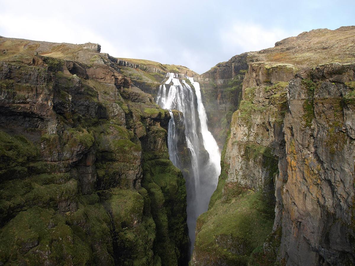
After the log crossing, the trail ascends steeply up the east side of the canyon. This section is the hardest part: 20 to 30 minutes of climbing on loose scree with a steep drop to your left. Hiking boots with good grip are essential. The trail then levels out and passes through a cave before reaching the first viewpoints of Glymur. The waterfall is about 198 m tall, falling in two tiers into the canyon. These viewpoints are the turn-back point for the there-and-back route.
If you continue the loop, the trail follows the canyon rim for another 30 minutes to the upper Botnsá crossing. This crossing uses stepping stones. In low water it is straightforward; in high water the stones are submerged and the crossing is unsafe. After crossing, the trail descends the west side of the canyon on a narrower, less maintained path back to the valley floor and the parking area. The full loop takes 3 to 4 hours.
What to Wear and Carry
- Hiking boots with grip for loose scree and wet rock. Not trail runners, not trainers.
- Water shoes or sandals for the log crossing. Bare feet work if the air temperature is above 10°C.
- An offline map downloaded before you leave Route 1. Mobile signal is patchy in the inner fjord and absent near the trailhead.
- Extra layers and a waterproof shell. Hvalfjörður weather changes quickly.
- Lunch and at least 1.5 litres of water. There is no water source on the trail that is safe to drink without treatment.
When to Turn Back
- The log is not in place. Do not attempt to wade the Botnsá. Stay on the east side for a there-and-back.
- The river is up. If the upper Botnsá crossing stones are covered, reverse direction and descend the east side.
- Fog obscures the viewpoints. The trail above the tree line is hard to follow in low visibility. Turn around at the cave or before the first viewpoints.
- Ice is present on the trail. The steep east-side sections become dangerous with ice. Turn around immediately.
- You run out of daylight. The hike takes 3 to 4 hours in good conditions. Start before noon.
Common Questions
When is the log across the Botnsá in place?
The log is placed in early June and removed before winter, typically in late September. The exact dates vary by year and snowmelt. In 2025 the log was in place from the first week of June through the third week of September.
Can I hike Glymur if the log is gone?
Yes, but only as a there-and-back on the east side. You cannot cross the lower Botnsá safely without the log. The east-side route climbs to the first viewpoints and the cave, then returns the same way. That takes 3 to 4 hours and still gives canyon views.
How hard is the Glymur hike?
Moderate to challenging. The round trip is 7 km with a steep climb, mostly on loose scree. The steep east-side climb and the log crossing require good balance and grip. Hiking boots are mandatory.
How long does the Glymur hike take?
3 to 4 hours for the full loop in dry summer conditions. 4 to 5 hours if the ground is wet or icy. The there-and-back east side takes about 2.5 to 3 hours.
Where do you park for Glymur?
At the end of the Botnsdalur road, in an unpaved car park. It fills by mid-morning on summer weekends. Arrive by 08:30. There are no facilities at the trailhead.
What happens if the weather turns bad on the trail?
Turn around. Fog obscures the viewpoints and the trail above the tree line is unmarked. Rain makes the scree slippery. Wind in the canyon can be strong enough to knock you off balance. The hike is not worth the risk in bad weather.
Is Glymur worth doing as a there-and-back?
Yes. The east-side viewpoints give a full view of the 198-metre waterfall and the canyon. The cave and the initial climb are part of both routes. Missing the west-side descent means missing the upper river crossing and a different angle on the canyon, but the there-and-back is still a good half-day hike from Reykjavík.
Read next
-
 Icelandic Place Names: The Word-Parts That Decode the Map
Icelandic place names are compounds that describe the place. Learn twenty word-parts and most of the map explains itself.
Icelandic Place Names: The Word-Parts That Decode the Map
Icelandic place names are compounds that describe the place. Learn twenty word-parts and most of the map explains itself.
-
 Icelandic Road Signs: The Words You Need Before You Drive
Iceland signs its hazards in Icelandic. Six words matter more than the rest, and two of them appear on the Ring Road hourly.
Icelandic Road Signs: The Words You Need Before You Drive
Iceland signs its hazards in Icelandic. Six words matter more than the rest, and two of them appear on the Ring Road hourly.
-
 Icelandic Phrases for Travellers, and When They Actually Help
Everyone in Iceland speaks English, so phrases are courtesy rather than necessity. These are the ones that land well.
Icelandic Phrases for Travellers, and When They Actually Help
Everyone in Iceland speaks English, so phrases are courtesy rather than necessity. These are the ones that land well.
-
 The Icelandic Alphabet: Þ, Ð, Æ, Ö and How to Read Them
Icelandic has four letters English does not, and every road sign uses them. What they sound like, how to type them, and where to go next.
The Icelandic Alphabet: Þ, Ð, Æ, Ö and How to Read Them
Icelandic has four letters English does not, and every road sign uses them. What they sound like, how to type them, and where to go next.