Visiting Vík í Mýrdal, the Black Sand Beach Village on Iceland’s South Coast
Understand the dangers of Reynisfjara’s sneaker waves and plan a safe, rewarding stop in Vík on Iceland’s south coast.
- Flag
-
- ISO code
- IS
- Population
- 750
- Currency
- ISK
- Timezone
- Atlantic/Reykjavik
Vík is Not a Danger Zone. the Beach Is.
Most visitors picture Reynisfjara as a single place: the black sand beach where you take the photo of basalt columns and frothing surf. That is the wrong map of the risk. The village of Vík í Mýrdal sits 5 km west of Reynisfjara. It is an ordinary, functional Icelandic settlement of 750 people. The danger is not Vík. The danger is the beach. It has killed five tourists between 2013 and 2022, the most recent in 2022. The sand is black basalt. The waves are Atlantic swells with no off switch. Do not confuse the two. The practical question is how to see Reynisfjara without becoming a statistic while using Vík as the logical base for the south coast.
Reynisfjara is a Known Fatality Site. Treat it Like One.
What You Are Dealing With
Reynisfjara is not a swimming beach. It is not a beach for wading. It is a geological exhibit with an unpredictable wave regime that has killed people who walked too close to the water. The term you need is sneaker wave. Sneaker waves surge significantly further up the beach than preceding waves, with no predictable pattern. A wave that stays 10 metres from your feet can be followed by one that covers 30 metres in seconds. The water is cold. The undertow is strong. If you are swept off your feet, you are in the Atlantic.
How to Stay Alive on the Sand
Icelandic authorities installed a traffic light warning system in 2021. Green, yellow and red zones are marked on the beach. Green is safe. Yellow means caution. Red means do not enter. The system works if you look at it. The bigger rule is simpler: never turn your back on the sea. Stay at least 30 metres from the water's edge. That distance is not a suggestion. It is the margin between a photograph and a search operation.
Five deaths in nine years is a high rate for a single beach. Do not let the basalt columns and sea stacks distract you. This is the most dangerous tourist site on the south coast. Arrive, take your photo from the safe zone at the far eastern end near the cave, keep your eyes on the water, and leave. Do not walk toward the waves for a better angle. The better angle is not worth it.


Why Vík is Your Overnight Stop: Distance, Logic and the Church on the Hill
Vík sits at 187 km from Reykjavík via Route 1 and 193 km from Jökulsárlón. That puts it at the midpoint of the most popular south coast drive. Leave Reykjavík after breakfast, hit Seljalandsfoss, Skógafoss and Reynisfjara, and arrive in Vík in the late afternoon. The next morning drive to Jökulsárlón and the glacier lagoon before turning back. That itinerary works because Vík has accommodation. The catch: fewer than 1,000 beds exist across all properties in the municipality of Mýrdalshreppur. June through August is fully booked three to six months in advance. Book by February for a summer trip. A double room in a guesthouse runs 25,000 to 45,000 ISK per night. The campsite charges 1,500 to 2,000 ISK per person.
Dyrhólaey: The Promontory You Should Not Skip
Drive 9 km west of Vík to Dyrhólaey, a 120 metre high promontory with a natural arch spanning roughly 50 metres. It is the best vantage point on the south coast. From the top you see the entire black sand coastline east to Reynisfjara and west to the Mýrdalssandur outwash plain. The Atlantic puffin nests here from May to mid-August. Arrive before 10:00 to avoid tour bus crowds. The road up is steep gravel. A standard 2WD car can manage it in dry conditions. Skip it if rain is forecast. The road becomes slippery and the parking area is small.
Víkurkirkja: The Building on the Hill
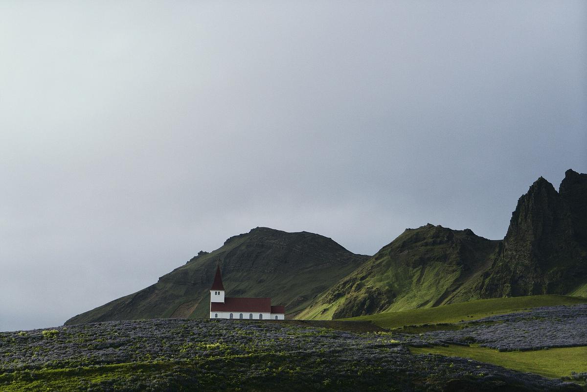
The red roofed church on the hill above Vík is Víkurkirkja, built in 1932. It sits at roughly 80 metres above sea level. Walk up from the village centre. The view covers the entire settlement, the black sand coastline and the Mýrdalsjökull glacier to the north. It takes 15 minutes. It is free. Do it at sunset if the weather is clear.
The Road East and What Can Stop You
Route 1 between Vík and Höfn is the stretch that closes most often. The causes: Katla jökulhlaup glacial outburst flood risk, sandstorms and winter blizzards. Katla is the volcano under Mýrdalsjökull. A jökulhlaup can wash out bridges and cover the road in sediment without warning. Sandstorms in the outwash plains reduce visibility to zero. Winter blizzards close the road for hours or days. Check road.is for real time updates. The map updates continuously. Check en.vedur.is for weather. The forecast updates at least every six hours. If road.is shows a red segment east of Vík, do not drive it. Wait in Vík. The village has petrol, a supermarket and places to eat where a basic meal costs 2,500 to 4,500 ISK. You are not stranded. You are waiting.
.jpg)
| Destination | Distance via Route 1 | Drive Time |
|---|---|---|
| Reykjavík | 187 km | 2 hours 15 minutes |
| Skógafoss | 25 km | 20 minutes |
| Reynisfjara | 5 km | 8 minutes |
| Dyrhólaey | 9 km | 12 minutes |
| Jökulsárlón | 193 km | 2 hours 20 minutes |
| Höfn | 240 km | 2 hours 50 minutes |
Common Questions
Is it safe to walk on Reynisfjara beach?
Yes, if you stay at least 30 metres from the water's edge, never turn your back on the sea and obey the traffic light warning system installed in 2021. The green zone is safe. The red zone is not. Five people died here between 2013 and 2022. Treat the beach as a hazard, not a playground.
What is a sneaker wave and why is it dangerous?
A sneaker wave surges significantly further up the beach than preceding waves, with no predictable pattern. It can cover 30 metres of dry sand in seconds. The water is cold Atlantic swell. If it takes your feet, the undertow pulls you out. No warning. No pattern.
How far in advance should I book accommodation in Vík?
For June through August, book three to six months ahead. The entire municipality has fewer than 1,000 beds. A guesthouse double room costs 25,000 to 45,000 ISK per night. The campsite costs 1,500 to 2,000 ISK per person. Book by February for a summer trip.
Can I see puffins at Dyrhólaey?
Yes, from May to mid-August. The species is the Atlantic puffin. Arrive before 10:00 to avoid crowds. The road up is gravel and steep. A 2WD car is fine in dry conditions. Skip it if rain is forecast.
What is Víkurkirkja and is it worth visiting?
Víkurkirkja is the church on the hill above Vík, built in 1932. It sits at roughly 80 metres above sea level. The walk from the village centre takes 15 minutes. It is free. The view covers the village, the coastline and Mýrdalsjökull. Go at sunset if the weather is clear.
How do I check road conditions east of Vík?
Use road.is. The map updates in real time. The road between Vík and Höfn closes due to Katla jökulhlaup risk, sandstorms and winter blizzards. Check en.vedur.is for weather forecasts updated every six hours. If road.is shows red, do not drive.
How much does petrol cost in Vík?
Pay by card. Cash is rarely needed.
Read next
-
 Iceland Accommodation Types from Farm Stays to Hostels
A hotel in rural Iceland rarely means what it means elsewhere. The real differences between guesthouses, farm stays, hostels and campsites before you book.
Iceland Accommodation Types from Farm Stays to Hostels
A hotel in rural Iceland rarely means what it means elsewhere. The real differences between guesthouses, farm stays, hostels and campsites before you book.
-
 Where to Stay in Iceland for a Ring Road Road Trip
On an Iceland lap, the road decides where you sleep. Which bases break the Ring Road into sensible chunks, and where inventory runs dangerously low in July.
Where to Stay in Iceland for a Ring Road Road Trip
On an Iceland lap, the road decides where you sleep. Which bases break the Ring Road into sensible chunks, and where inventory runs dangerously low in July.
-
 Keflavik Airport Flights Transfers and Iceland Domestic Routes
Keflavík to Reykjavík has no train. Flybus, taxi costs, rental car pickup, and when a domestic flight from Reykjavík City Airport saves a day of driving.
Keflavik Airport Flights Transfers and Iceland Domestic Routes
Keflavík to Reykjavík has no train. Flybus, taxi costs, rental car pickup, and when a domestic flight from Reykjavík City Airport saves a day of driving.
-
 Iceland Experiences Worth Booking and Those That Depend on Weather
Some Iceland experiences vanish if you don't book weeks ahead. Silfra, ice caves, and Landmannalaugar huts sell out. Waterfalls and beaches just need you to show up.
Iceland Experiences Worth Booking and Those That Depend on Weather
Some Iceland experiences vanish if you don't book weeks ahead. Silfra, ice caves, and Landmannalaugar huts sell out. Waterfalls and beaches just need you to show up.
-
 Best Time to Visit Iceland Month by Month With Daylight Hours
Iceland changes radically by month. This calendar covers daylight hours, road openings, puffin season, northern lights windows, and the two summer weekends that book out nationwide.
Best Time to Visit Iceland Month by Month With Daylight Hours
Iceland changes radically by month. This calendar covers daylight hours, road openings, puffin season, northern lights windows, and the two summer weekends that book out nationwide.
-
 Getting Around Iceland by Car F-Roads Wind and Road.is
Driving Iceland means understanding F-road legality, reading road.is, and respecting wind that can rip a door off its hinges. This guide covers what rental agencies won't tell you.
Getting Around Iceland by Car F-Roads Wind and Road.is
Driving Iceland means understanding F-road legality, reading road.is, and respecting wind that can rip a door off its hinges. This guide covers what rental agencies won't tell you.
-
 Iceland Schengen Visa Rules and the Upcoming ETIAS Requirement
Iceland is in the Schengen Area but not the EU customs union. Here is exactly what you need at Keflavík passport control, including the new ETIAS pre-authorisation.
Iceland Schengen Visa Rules and the Upcoming ETIAS Requirement
Iceland is in the Schengen Area but not the EU customs union. Here is exactly what you need at Keflavík passport control, including the new ETIAS pre-authorisation.
-
 Money in Iceland ISK Cards and Where the Spending Actually Goes
Iceland runs on cards, not cash, but chip-and-PIN fuel pumps and state liquor store hours catch travellers out. Here is where your króna actually goes.
Money in Iceland ISK Cards and Where the Spending Actually Goes
Iceland runs on cards, not cash, but chip-and-PIN fuel pumps and state liquor store hours catch travellers out. Here is where your króna actually goes.
-
 Iceland Itinerary for 5 7 10 and 14 Days
Five days means the South Coast only. Seven is a rushed lap. Ten adds a peninsula. Fourteen opens the Westfjords. What each Iceland itinerary realistically delivers.
Iceland Itinerary for 5 7 10 and 14 Days
Five days means the South Coast only. Seven is a rushed lap. Ten adds a peninsula. Fourteen opens the Westfjords. What each Iceland itinerary realistically delivers.