Walking Up Through Dynjandi’s Seven Cascading Falls
Dynjandi is a cascading bridal-veil waterfall in the Westfjords reached by a stepped walk past six smaller falls, with a long gravel-road approach.

Walking Up Through Dynjandi’s Seven Cascading Falls
The gravel pops under your tyres as you crest the Dynjandisheiði pass, a barren moonscape of moss and rock at 500 metres. The road narrows. The wind tests the door seal. Then you see it: a white ribbon unspooling down a fan-shaped cliff, widening from 30 metres at the top to 60 metres at the base. This is Dynjandi, and getting here is half the story.
Dynjandi is the signature waterfall of the Westfjords. Unlike the south coast falls that sit right off the Ring Road with paved paths and coach parking, Dynjandi demands a real commitment. The access road, Route 60 over the Dynjandisheiði pass, is gravel. It opens late May or early June and closes with the first snow, usually September or October. No winter alternative exists. No fuel stations for miles past the turnoff. Drive here deliberately, not casually. That is exactly why it rewards.
The Climb
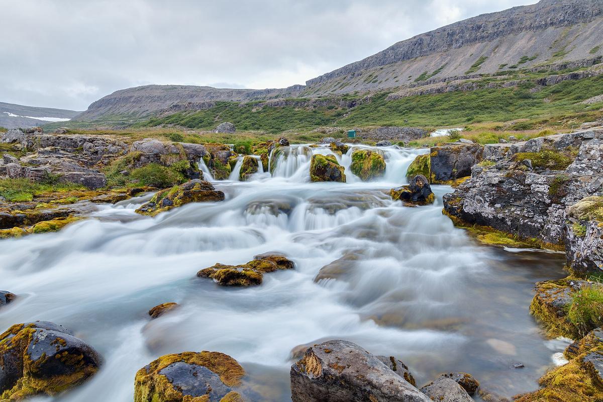
The walk from the car park to the top platform is 1.5 kilometres one way, with 200 metres of elevation gain. Allow 15 to 20 minutes up and 10 to 15 minutes back down. The trail passes six named waterfalls before you reach Dynjandi itself. From bottom to top they are: Bæjarfoss, Hundafoss, Hrísvaðsfoss, Göngumannafoss, Strompgljúfrafoss, Háifoss, and then Dynjandi. Each tier has its own character, but the walk is a steady ascent without switchbacks. You climb alongside the cascade, close enough to feel the mist shift from light spray to full soak as you rise.
At the Top Platform
The real experience is at the top. Dynjandi's uppermost tier drops roughly 60 metres of the total 100-metre height. The wind at that platform is relentless. It catches the falling water and throws it sideways. You will be wet. Your camera lens will need a wipe before every shot. The spray is not a drizzle. It is a constant, cold blast that turns the stone platform into a slick surface. Hold the railing. Wear a waterproof jacket with a hood and something that seals at the wrists. The walk down is easier, faster, and drier, but if the wind is up, keep one hand on the trail side.
- Total Height: ~100 m
- Height of Dynjandi (Upper Tier): ~60 m
- Width at Top / Base: 30 m / 60 m
- Named Waterfalls on Trail: 7 (Bæjarfoss, Hundafoss, Hrísvaðsfoss, Göngumannafoss, Strompgljúfrafoss, Háifoss, Dynjandi)
- Trail Length (One Way): ~1.5 km
- Elevation Gain: ~200 m
- Walking Time Up / Down: 15, 20 min / 10, 15 min
- Road Number: Route 60 (Vestfjarðavegur)
- Pass Elevation: ~500 m
- Typical Season: Late May/early June to September/October
- Winter Access: None. Road closed, no winter service.
- Facilities at Car Park: Toilets (fee), picnic tables
- Nearest Campsites: Þingeyri (~35 km) or Flókalundur (~40 km)
- Distance from Brjánslækur Ferry: ~45 km
- Distance from Ísafjörður: ~70 km
- Best Light for Photography: Late afternoon to evening (west-facing)
- Typical Visitor Numbers: Low: a few hundred per day in peak season
What the Gravel Road Demands
Route 60 to Dynjandi is a gravel road over the Dynjandisheiði pass. It is not an F-road (those require a 4x4 and special insurance), but it is rough enough that a standard two-wheel-drive car will feel the rattle. Drive slower than you think you need to. The surface is loose, blind crests are common, and oncoming traffic kicks up dust clouds that reduce visibility to zero. The pass sits at 500 metres, which means weather changes fast. One minute you are in low cloud, the next in full sun.
Fuel Strategy
There is no fuel at Dynjandi. The nearest stations are in Þingeyri, about 35 kilometres north, or Flókalundur, about 40 kilometres south. Fill up before you turn off the main Ring Road. The rule for the Westfjords generally: never let your tank drop below half. Stations close early and many are unmanned; you need a chip-and-PIN credit card to operate the pumps. Contactless cards often fail. Have the physical PIN ready.
When the Road Closes
The pass opens late May or early June and closes by September or October, depending on snow and ice. Do not attempt it outside those months. There is no winter maintenance. No alternative route. If the pass is closed, Dynjandi is unreachable by car. Check road.is before you leave your accommodation. The forecast on that site is more reliable than any weather app.
What You Find at the Car Park and Trailhead
The parking lot is small and unpaved. It has a toilet block (fee applies, card or coin) and a few picnic tables. There is a donation box. No entry fee. No ticket booth. No guardrails. No paved walkways.
This is not the south coast. At Seljalandsfoss or Skógafoss, you pay for parking via an app and walk on groomed paths with metal railings. At Dynjandi, the trail is gravel and rock, the edges are unmarked, and the only thing stopping you from slipping into a cascade is your own footing. That is the appeal. But it is also the risk. Wear proper shoes. Trail runners or hiking boots with good grip. The rock near the platforms gets slick with spray and moss.
Planning Your Stop
No designated campsite exists at the waterfall. The nearest camping is in Þingeyri (35 km) or Flókalundur (40 km). If you are driving the Westfjords loop, Dynjandi sits between the Brjánslækur ferry terminal (45 km south) and Ísafjörður (70 km north). Plan your overnight stop accordingly. The region has sparse services: no grocery store within an hour's drive, no restaurant at the site. Pack food and water.

Photographing Dynjandi: Light, Wind, and Spray
Dynjandi faces west. That means late afternoon and early evening deliver the best light. The sun hits the falling water from behind you, illuminating the full fan shape. Midday sun is harsh and flat. Early morning is dark in the valley shadow. Arrive between 16:00 and 19:00 for optimal conditions.
Protecting Your Gear
The wind and spray are not just atmospheric. They are a gear problem. The platform at the top of the trail is a constant spray zone. A standard camera cover is insufficient. Use a rain sleeve or a waterproof housing. Bring a microfiber cloth for the lens. Your phone will stop registering touch input if the screen gets wet; turn on waterproof mode if your model has one, or keep it sealed in a dry bag until you reach the platform. The spray at the top is heavier than at any lower tier. You will not take a dry photograph up there. Plan for it.
Visitor numbers are low. A few hundred people per day in peak season. That means no crowd jostling for the perfect frame. You can set up a tripod without someone walking into your shot. But the wind will test the tripod's stability. A centre column hook for a weight bag is not optional. It is necessary.
Common Questions
How long is the walk up to Dynjandi?
The trail from the car park to the top viewpoint is 1.5 kilometres one way with about 200 metres of elevation gain. Walking up takes 15 to 20 minutes. Walking down takes 10 to 15 minutes.
Is the gravel road to Dynjandi suitable for a regular car?
Route 60 over the Dynjandisheiði pass is a gravel road, not an F-road. A standard two-wheel-drive car can make it if you drive slowly. The surface is loose and there are blind crests. A 4x4 gives you more comfort but is not legally required.
Can you visit Dynjandi in winter?
No. The pass closes with snow and ice, usually by September or October, and does not reopen until late May or early June. There is no winter maintenance and no alternative route. Check road.is for real-time conditions.
Where can you stay near Dynjandi?
There is no designated campsite at Dynjandi. The nearest campsites are in Þingeyri, about 35 kilometres north, and Flókalundur, about 40 kilometres south. Guesthouses and farm stays are scattered along Route 60 but book ahead in summer.
What facilities are at the Dynjandi car park?
The parking lot has a toilet block (fee payable by card or coin), picnic tables, and a donation box. No fuel, no restaurant, no shop. There is no entry fee, no paved walkways, and no guardrails on the trail.
Read next
-
 Latrabjarg Bird Cliffs
Látrabjarg lets you photograph puffins from a metre away during their ten-week nesting window, but the unfenced cliff edge demands caution.
Latrabjarg Bird Cliffs
Látrabjarg lets you photograph puffins from a metre away during their ten-week nesting window, but the unfenced cliff edge demands caution.
-
 Iceland Accommodation Types from Farm Stays to Hostels
A hotel in rural Iceland rarely means what it means elsewhere. The real differences between guesthouses, farm stays, hostels and campsites before you book.
Iceland Accommodation Types from Farm Stays to Hostels
A hotel in rural Iceland rarely means what it means elsewhere. The real differences between guesthouses, farm stays, hostels and campsites before you book.
-
 Where to Stay in Iceland for a Ring Road Road Trip
On an Iceland lap, the road decides where you sleep. Which bases break the Ring Road into sensible chunks, and where inventory runs dangerously low in July.
Where to Stay in Iceland for a Ring Road Road Trip
On an Iceland lap, the road decides where you sleep. Which bases break the Ring Road into sensible chunks, and where inventory runs dangerously low in July.
-
 Keflavik Airport Flights Transfers and Iceland Domestic Routes
Keflavík to Reykjavík has no train. Flybus, taxi costs, rental car pickup, and when a domestic flight from Reykjavík City Airport saves a day of driving.
Keflavik Airport Flights Transfers and Iceland Domestic Routes
Keflavík to Reykjavík has no train. Flybus, taxi costs, rental car pickup, and when a domestic flight from Reykjavík City Airport saves a day of driving.
-
 Iceland Experiences Worth Booking and Those That Depend on Weather
Some Iceland experiences vanish if you don't book weeks ahead. Silfra, ice caves, and Landmannalaugar huts sell out. Waterfalls and beaches just need you to show up.
Iceland Experiences Worth Booking and Those That Depend on Weather
Some Iceland experiences vanish if you don't book weeks ahead. Silfra, ice caves, and Landmannalaugar huts sell out. Waterfalls and beaches just need you to show up.
-
 Best Time to Visit Iceland Month by Month With Daylight Hours
Iceland changes radically by month. This calendar covers daylight hours, road openings, puffin season, northern lights windows, and the two summer weekends that book out nationwide.
Best Time to Visit Iceland Month by Month With Daylight Hours
Iceland changes radically by month. This calendar covers daylight hours, road openings, puffin season, northern lights windows, and the two summer weekends that book out nationwide.
-
 Getting Around Iceland by Car F-Roads Wind and Road.is
Driving Iceland means understanding F-road legality, reading road.is, and respecting wind that can rip a door off its hinges. This guide covers what rental agencies won't tell you.
Getting Around Iceland by Car F-Roads Wind and Road.is
Driving Iceland means understanding F-road legality, reading road.is, and respecting wind that can rip a door off its hinges. This guide covers what rental agencies won't tell you.
-
 South Iceland
How to drive Iceland's South Coast from Seljalandsfoss to Skaftafell, with honest timings, parking logistics, and the stops worth pulling over for.
South Iceland
How to drive Iceland's South Coast from Seljalandsfoss to Skaftafell, with honest timings, parking logistics, and the stops worth pulling over for.
-
 Capital Region
How to spend your arrival and departure days in Reykjavík, from the Miðborg walking loop to Vesturbær's local pools and the domestic airport at RKV.
Capital Region
How to spend your arrival and departure days in Reykjavík, from the Miðborg walking loop to Vesturbær's local pools and the domestic airport at RKV.